March 12, 2026.
This article provides a brief description of how the “Follow-the-Crumbs” exploration workflow / approach developed by YTF Exploration Consulting led to the identification of the “elusive” Upper Jurassic Play trend in the South Viking Graben (SVG) area of the Norwegian Continental Shelf (NCS).👏
➡️ What is “Follow-the-Crumbs”?: Follow-the-Crumbs is an investigative review of dry exploration wells, well with shows, and minor discoveries, with the aim of identifying causes, possible missed targets, and nearby lead opportunities. The approach uses a series of key questions aimed at evaluating how well results align with regional geological observations and other fundamental geological principles.👏
➡️ Background: The Upper Jurassic play of the South Viking Graben (SVG) represents a deep marine turbidite trend. Sourced predominantly from the Utsira High, eroded sediments are deposited in fault terraces flanking the intra-basinal high areas that formed on the rift margin as the rift progressed… with the eroded sediments finding their way down into the basin. Until recently, targeting the Upper Jurassic play of the South Viking Graben area of the NCS has been difficult for explorers…for various reasons.
(1) First, the play is a deepwater turbidite trend with difficult to map play fairway.
(2). The quality of the previously available seismic data coverage was not suitable for mapping deepwater turbidites..i.e. sub-BCU imaging was degraded, and the seismic resolution wasn’t good enough for some of the clues and indications that you would look for to identify source areas, routing agents, and possible depositional areas.
(3) Not a lot of wells targeting the UpperJurassic in the study area.
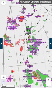
Conoco Norway drilled 25/7-1 S wildcat well in 1986 based on a play concept where Upper Jurassic sands were thought be present on the downthrown fault block northwest of the Balder field in the North Sea. The well turned out to be dry, as Jurassic to Devonian rocks were missing / eroded… Cretaceous was found resting directly on the Basement rocks. In 1990, Conoco Norway, still on the chase for the “elusive” Upper Jurassic sands, drilled the 25/7-2 wildcat well. The well found gas/condensate but in very poor reservoir rocks. (Figures 1 a – c). Acreage positions and other relevant info are shown in figures 2 a – c.
➡️ Data: Subsurface data used for the project include – well log data, core data, seismic data, structural maps, fault interpretations, etc.. In addition, already identified leads and prospects by other explorers were included in the review work. Available seismic data from the area was also integrated.
Data Sources: Norwegian Offshore Directorate, Data on relinquished blocks (also from the NOD), other publicly available data, and research data from various sources.
➡️ Methodology: The wells used for this project were divided into two classes, – key wells and relevant wells. Two of the key wells used are well 25/7-1 S and well 25/7-2.. both wells targeted the Upper Jurassic in the South Viking Graben area located just west of the Utsira High. As part of the workflow, the aim was to put the key well(s) in regional context (structurally and stratigraphically).
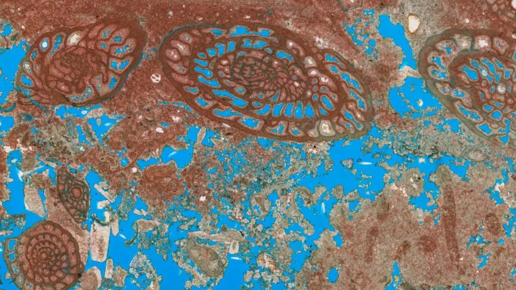
– The key well, 25/7-2, was drilled by Conoco Norway in 1990. The well encountered gas/condensate in Upper Jurassic unit that was described as – “derived from debris flow and slump / slide deposits”. See well log data in Figure 3. Review of log data and core data from the well indicate that the Upper Jurassic series that was penetrated was largely derived from footwall instability / collapse (see core data in Figures 4 a – g). From the core photos, one can clearly see ripped-up mud clasts, overturned deposits, large clasts and conglomerates, collapse deposits, and other debris flow type units… all these must have been derived from nearby source locations (close to the footwall).. with better reservoir facies located further out downdip👏 Core data for well 25/7-1 S is shown in Figures 5 a – d.
By integrating the analysis of the well data information (log+core) with the mapped structural framework / trends, as well as the seismic data, it was possible to map source areas, sediment routes, and possible depositional areas.
➡️ Results: Here are some key findings from the project ⤵️
– Source Area: Utsira High.
– Sediment Routes: Key sediment entry points are via (1) fault relay ramps, and (2) footwall instability and collapse due to uplift of rift margin.
– Depositional Areas: Along fault terraces and intra-basinal mini basins. Along fault terraces, reservoir quality can be influenced by a few factors.
The investigative review of subsurface data from the key wells and other relevant wells led to the identification and highgrading of lead opportunities within the study area. Coincidentally, one of those identified lead opportunities was later selected for drilling by DNO Norge in 2023 resulting in the “Norma” discovery well (gas/condensate), which was rightly described as a play opener at that time.👏 Needless to say, I was elated to hear the news of the discovery… and I later had the opportunity to make mention of my work in the area while in a meeting at DNO offices… It’s also why I’m excited about the upcoming “Norma Appraisal” well and I’ve included it on my list of wells to watch this year.👏 Current size estimates for “Norma” discovery is 2 – 21 million scm…👏
➡️ Additional Opportunities: Several other Upper Jurassic Lead Opportunities have been identified and highgraded in this area of the South Viking Graben and are available as part of my offerings for Jurassic play opportunities in the North Sea. 👉Let’s have a chat if you’d like to hear more and view these offerings – “consulting@ytfexploration.com”.
➡️ Note: The “Follow-the-Crumbs” exploration workflow / approach can also be applied in other areas of the NCS (play by play) for identifying and highgrading drillibg opportunities in your acreage or area of interest…👉 Contact – “consulting@ytfexploration.com“.
➡️ Related Posts: Check my previous posts featured on my LinkedIn profile…where I’ve shared about some of the exploration techniques used in this project – i.e., repost of Rene Jonk’s video on “Deepwater Reservoirs: Architecture of Syn-Kinematic Reservoir and Traps” (Link) 👏, and my repost of the TGS article on “Deep Upper Jurassic Play Evaluation in the South Viking Graben” (Link). 👏
Images
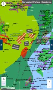
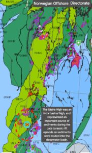
Figs. 1 a -c. Link 1a. Link 1b. Link 1c
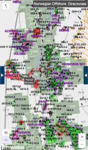
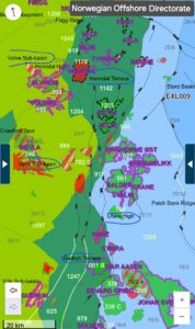
Figs. 2 a – c. Link 2a. Link 2b. Link 2c.
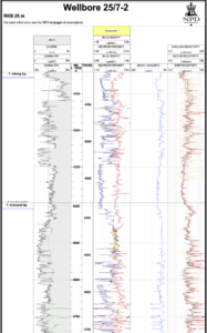
Fig. 3. Link 3.
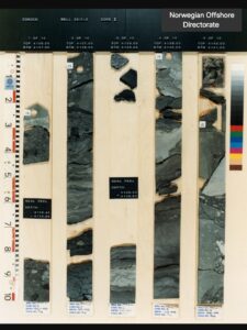
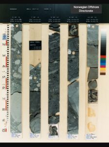
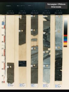
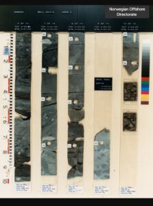
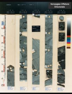
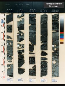
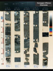
Fig. 4 a – g. Link 4a. 4b. 4c. 4d. 4e. 4f. 4g.
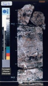
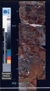
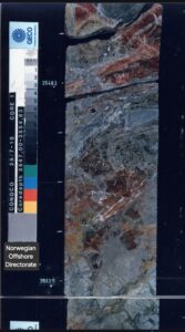
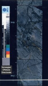
Fig. 5 a – d.
Tags: #NCS #Exploration #JurassicPlays #LateJurassicPlays #Prospectivity #SouthVikingGraben #NorthSea #Leads #Prospects #ProspectReview #PlayReviews #PlayBasedExploration #HighgradedLeads #PlayFairway
Featured Image: NCS Map with insert photo of Deepsea Yantai rig used for Norma discovery well. Source – Odfjell Drilling…. and core photo from well 25/7-2.